

Locally Grounded Forest Carbon (LGFC)
Tesera is introducing a new collaborative offering, Locally Grounded Forest Carbon (LGFC). The solution combines our High-Resolution Inventory Solutions (HRIS) on-the-ground measurements with Forest Carbon datasets (one of the Planetary Variables from Planet Labs).
LGFC offers a more precise and complete understanding of forest and carbon resources. Initial findings demonstrate a significant increase in local-scale accuracy.
The solution provides clients with quarterly updates on canopy height and cover, above ground live carbon, sourced from optical, radar, passive microwave and LiDAR sensors. By localizing the Planet global dataset with ground measurements, LGFC also enhances accuracy in absolute values (while preserving the original precision in relative values).
LGFC takes Forest Carbon data and localizes it with a client’s ground-measured data. The client provides an area of interest and compiled ground plot data. Tesera runs an analysis on the compiled ground plot data (versus the Forest Carbon covariates) to create an adjustment model. This model is then applied to adjust the Forest Carbon data to a more accurate, localized version. This process also generates a surface of standard errors, which allows users to see where the data is most and least accurate.
The uniqueness of this solution lies in its innovative approach of using ground plots and Tesera’s expertise and advanced analytics to fill the accuracy gap between space-based and on-the-ground measurements. Initial findings demonstrate a significant increase in local-scale accuracy when using LGFC. For example, in a Northern Ontario, Canada test area, LGFC demonstrated that strategically placed fixed-radius HRIS plots ground measurements can augment Planet Forest Carbon, reducing prediction errors for carbon values by 30% (as compared to the use of satellite-based Forest Carbon alone).
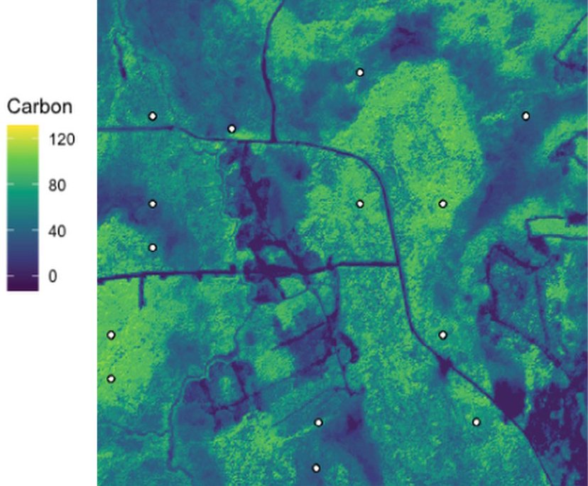
A visualization of carbon density, calibrated with ground plots.
TRADITIONAL FOREST INVENTORIES RISK INACCURATE CARBON ESTIMATES AND LOWER MARGINS
Traditional forest and carbon inventories often rely on low-resolution surveys and subjective extrapolations from ground samples, resulting in inaccuracies and limited scalability. In addition, this conventional approach can lead to poor management decisions and lower margins. For organizations involved in carbon markets, the lack of verifiable data prevents effective participation and measurement of carbon estimates.
Without a better solution, the expense, time, and errors associated with data collection and analysis only increase.
While many believe that a global, space-based dataset is all that’s required to manage large-scale forest assets, a critical insight reveals that the real challenge isn’t a lack of data, but a need for a bridge between global scale and local precision.
Planetary Variables® data provides highly detailed relative values at a global scale, making them a powerful tool for broad area monitoring. However, for specific, high-stakes applications like verified carbon markets, the feasibility of local-level compliance and verification requires a different kind of measurement. The true opportunity is to combine the power of a daily, global view from space with the on-the-ground truth needed for reliable outcomes.
ENHANCING FOREST AND CARBON MARKET ACCURACY WITH LOCALLY GROUNDED FOREST CARBON
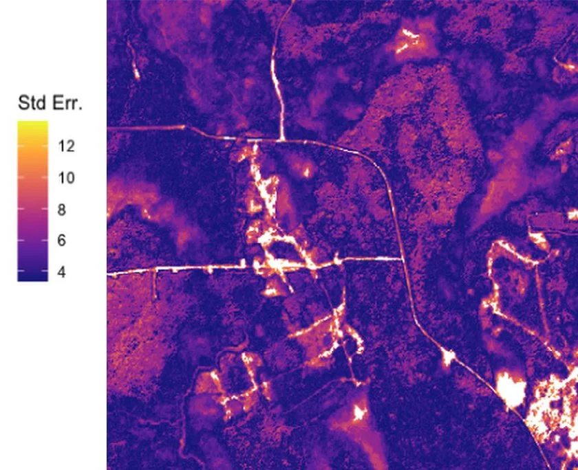
A visualization of the standard errors, showing areas where more ground plot data is needed to increase accuracy
The solution can be leveraged by professionals in forest and landscape planning; ecosystem services, mitigation banking, and carbon sequestration; forest harvest optimization and scheduling; and others. It provides clients with greater assurance that the data they are purchasing is grounded and at the accuracy level required for confident decision-making.